GalaxEye Mission Drishti: World's First OptoSAR Satellite
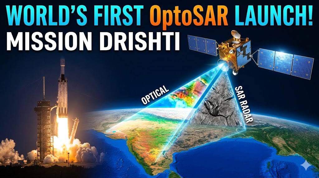
On May 3, 2026, a quiet revolution in Earth observation lifted off from Vandenberg Space Force Base in California. Aboard a SpaceX Falcon 9 rocket, as part of the CAS500-2 mission, India's GalaxEye successfully deployed Mission Drishti — the world's first OptoSAR satellite.
Weighing around 190 kilograms and built entirely by a Bengaluru-based startup, this satellite isn't just another addition to the growing constellation of Earth-imaging spacecraft. It represents a fundamental shift in how we see our planet, merging the best of two powerful imaging technologies into one seamless platform. For a country like India, prone to monsoons, dense cloud cover, and diverse terrains, this capability arrives as a game-changer.
In the following sections, we'll explore the story behind GalaxEye, the groundbreaking OptoSAR technology, the details of the launch, its potential applications, and what this milestone means for India's private space sector and the global Earth observation industry.
The Birth of GalaxEye: From IIT Madras to Orbit
GalaxEye Space Technologies was founded in 2021 by a group of passionate engineers, primarily alumni of the Indian Institute of Technology (IIT) Madras. At the helm is Suyash Singh, the CEO and Co-Founder, whose journey from building India's first hyperloop pod prototype for the SpaceX competition to developing advanced satellite sensors reflects a relentless drive for innovation.
The team, including co-founders like Denil Chawda (CTO), identified a critical gap in existing Earth observation solutions. Traditional satellites often force users to choose between high-resolution optical imagery (clear and intuitive but useless under clouds or at night) and Synthetic Aperture Radar (SAR) data (reliable in all conditions but harder to interpret). This limitation was particularly acute for tropical regions like India.
Inspired by challenges such as wildfire damage assessment — where smoke obscures optical views — the founders began developing what would become SyncFused OptoSAR technology. They validated concepts through hundreds of test flights on drones, aircraft, and high-altitude platforms, even flying a precursor payload on an ISRO PSLV mission. By early 2026, Mission Drishti was ready for its journey to space.
This homegrown effort highlights the maturing Indian startup ecosystem, supported by policy reforms that encourage private participation in space activities.
Understanding OptoSAR: The Technology That Changes Everything
At its core, Mission Drishti features a proprietary OptoSAR payload — the first commercial system to co-locate a high-resolution SAR sensor and a 7-band multispectral imager on a single satellite.
How traditional systems work (and fall short):
Electro-Optical (EO)/Multispectral Imaging: Captures images in visible and near-infrared bands, providing color, texture, and vegetation insights. However, clouds, darkness, or smoke render it blind.
Synthetic Aperture Radar (SAR): Uses microwave signals to "see" through obstacles, operating day or night and in any weather. The data, however, requires expertise to interpret and often needs fusion with optical data from different satellites, introducing parallax errors and time gaps.
OptoSAR's breakthrough lies in SyncFusion™ technology. Both sensors capture the exact same location simultaneously from the same platform. Onboard and ground-based AI handle precise co-registration, creating fused, analysis-ready datasets with three times more information than single-sensor alternatives.
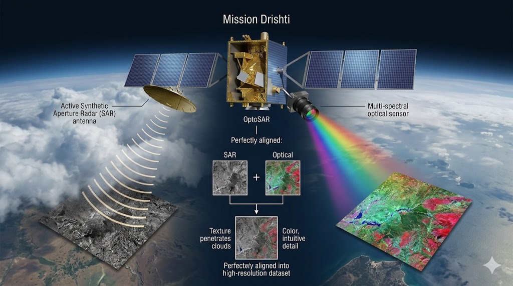
A technical deep-dive illustration demonstrating GalaxEye’s proprietary SyncFusion™ technology.
Key technical specifications of Mission Drishti include:
Mass: ~190 kg (India's largest privately developed EO satellite)
Orbit: Sun-synchronous Low Earth Orbit (LEO) at approximately 500
Resolution: Fused data around 1.8 m; SAR up to 0.9 m in spotlight mode
Bands: X-Band SAR (VV polarization), plus PAN, RGB, NIR, Coastal Blue, Red Edge for multispectral
Swath: SAR ~30 km, MSI ~10 km
Revisit: Targeted at 4 days globally
Modes: Stripmap and Spotlight for SAR
This integration eliminates manual data alignment headaches for users and accelerates applications like AI training for object detection and change monitoring.
The Historic Launch: May 3, 2026
The Falcon 9 lifted off smoothly from SLC-4E at Vandenberg, carrying Drishti among dozens of payloads. Deployment was confirmed shortly after separation, with GalaxEye teams monitoring the satellite's health in real-time.
Images released post-launch show the satellite gracefully moving away from the rocket stage against the blackness of space. Prime Minister Narendra Modi and ISRO leaders congratulated the team, underscoring its significance for Atmanirbhar Bharat and the private space economy.
For a young startup, riding with SpaceX marked both ambition and pragmatism — leveraging proven commercial launch services while focusing engineering prowess on the payload.
Why This Matters: Applications Across Sectors
Mission Drishti's all-weather, day-night capability opens doors across industries.
Defense and Security: Persistent monitoring of borders, maritime domains, and strategic areas regardless of conditions. The fused data enhances intelligence, surveillance, and reconnaissance (ISR) with greater contextual confidence. Indian defense agencies have shown keen interest.
Disaster Management: During floods, cyclones, or wildfires, optical satellites often fail when needed most. Drishti can penetrate clouds to assess damage, map inundation, and support rapid response efforts.
Agriculture: Precise crop health monitoring via multispectral bands, combined with SAR for soil moisture and structural insights, even under overcast skies. This supports better yield prediction, insurance claims, and precision farming.
Infrastructure and Urban Planning: Monitoring construction progress, detecting subsidence, or assessing damage after events becomes more reliable and frequent.
Environmental Monitoring: Tracking deforestation, glacial changes, or pollution with consistent data streams.
Commercial and AI Development: Easier-to-interpret fused imagery speeds up machine learning model training for automated target recognition (ATR) and change detection.
GalaxEye has already initiated an Early Adopters Program, offering access to initial datasets for partners worldwide.
Broader Impact on India's Space Ecosystem
Mission Drishti is more than a satellite launch; it's validation of India's New Space reforms. Private companies are no longer just suppliers but full mission developers. GalaxEye's success, alongside others, signals growing confidence from investors and government users.
The company plans a constellation of OptoSAR satellites to improve revisit times and coverage, aiming for significant expansion by 2030. This trajectory positions India as a potential exporter of advanced geospatial intelligence.
Economically, reliable Earth observation data can unlock billions in value across sectors. For a nation with vast agricultural lands, long coastlines, and diverse geography, sovereign capabilities reduce dependency on foreign providers.
Challenges and the Road Ahead
Space is unforgiving. Post-launch commissioning, orbit adjustments, payload calibration, and data validation will take weeks. Maintaining the satellite, managing downlink, and scaling processing infrastructure present ongoing hurdles.
Competition is fierce, with established players offering SAR or optical constellations. GalaxEye's edge lies in the unique fused product and focus on usability for non-expert analysts.
Future iterations may include higher resolutions, additional bands, or enhanced onboard processing with AI.
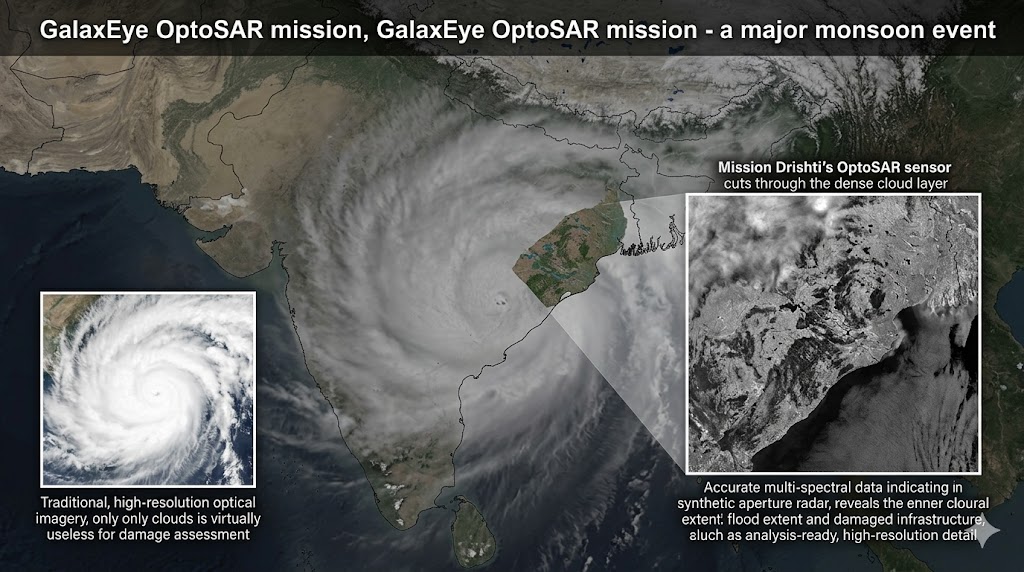
A critical application visualization of Mission Drishti (OptoSAR). During a monsoon flood event in India, traditional optical imagery (inset, right) is blinded by dense cloud cover.
Mission Drishti embodies the spirit of Indian ingenuity — solving real problems with elegant, integrated technology. By delivering intuitive, reliable imagery anytime, anywhere, it moves Earth observation from occasional snapshots toward continuous, actionable intelligence.
As the satellite begins its operations in the coming days and weeks, the world will watch closely. For GalaxEye, this is just the beginning. For India, it's another proud step in its journey as a spacefaring nation powered by its youth and private enterprise.
The skies above us have never been more transparent, thanks to a small but powerful satellite named Drishti — Sanskrit for "vision."