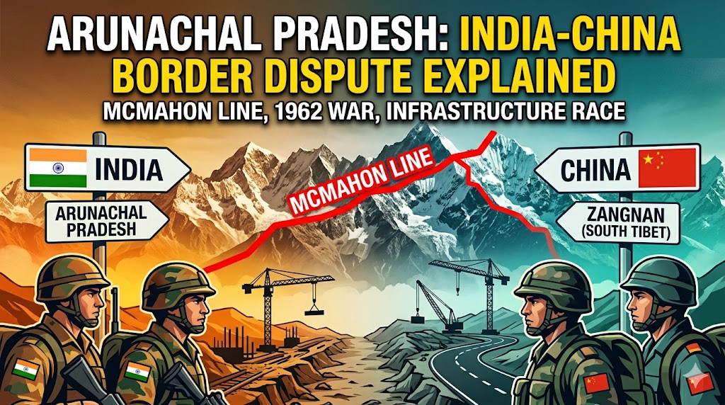
Arunachal Pradesh: India-China Border Dispute Explained
The rugged Himalayan terrain of Arunachal Pradesh has long stood as more than just a scenic frontier for India. It represents a profound test of sovereignty, history, and national resolve in the face of one of Asia’s most intractable territorial disputes. For decades, the India-China Arunachal Pradesh border dispute has cast a long shadow over bilateral relations between the world’s two most populous nations. What began as a colonial-era boundary disagreement has evolved into a complex web of historical claims, military clashes, diplomatic standoffs, and modern infrastructure rivalries that continue to shape regional security dynamics even in 2026.
At the heart of the matter lies China’s persistent assertion that nearly 90,000 square kilometers of Arunachal Pradesh—referred to by Beijing as “Zangnan” or South Tibet—belongs to it. India, conversely, maintains that the state is an integral and inalienable part of its territory, with the McMahon Line serving as the established boundary. This fundamental divergence has fueled everything from the 1962 Sino-Indian War to periodic border incursions and heated exchanges over place names and construction projects. Far from a relic of the past, the Arunachal Pradesh border dispute remains a live wire, influencing trade negotiations, military postures, and even cultural exchanges between New Delhi and Beijing.
Understanding this conflict requires delving into its historical roots, the pivotal events that escalated it, and the ongoing strategies both sides employ to assert control. From China’s pre-independence claims rooted in Tibetan historical ties to India’s rejection of Beijing’s renaming tactics and the parallel race to build roads and bridges along the Line of Actual Control (LAC), the dispute underscores deeper questions of power, legitimacy, and coexistence in the Himalayas. This article examines how the land matter has defined—and continues to strain—India-China political relations, offering a clear-eyed analysis of its origins, flashpoints, and implications.
Historical Background: Seeds of the Dispute Before and After Independence
The origins of the India-China Arunachal Pradesh border dispute trace back well before India gained independence in 1947. During the British colonial period, the Simla Convention of 1914 emerged as a key moment. British representative Sir Henry McMahon negotiated a boundary line with Tibetan delegates that placed the region south of the line—encompassing what is now Arunachal Pradesh—under British Indian administration. China, however, never formally ratified the agreement, viewing it as an illegitimate imposition by a foreign power over Tibetan affairs. Beijing has consistently argued that the McMahon Line lacks legal validity because Tibet was not a fully sovereign entity capable of concluding treaties independently.
This colonial legacy created a fault line that independent India inherited. Upon independence, New Delhi upheld the McMahon Line as the de facto border, integrating the North-East Frontier Agency (NEFA, later renamed Arunachal Pradesh in 1987) into its administrative framework. China, meanwhile, maintained its historical claim, portraying the area as an extension of southern Tibet based on cultural, religious, and administrative ties dating back centuries. Tawang, for instance, holds particular significance for China due to its association with the sixth Dalai Lama’s birthplace in the 17th century.
In the early years after 1947, both nations attempted diplomatic engagement, but mutual suspicions—exacerbated by China’s annexation of Tibet in 1950—prevented resolution. India saw the region as vital for its northeastern security and connectivity to Southeast Asia, while China viewed control over it as essential for consolidating its hold on Tibet and securing strategic depth. By the late 1950s, Chinese maps began depicting large swathes of NEFA as Chinese territory, setting the stage for confrontation. The Arunachal Pradesh border dispute, thus, was never merely about land; it embodied competing visions of post-colonial boundaries and national identity.
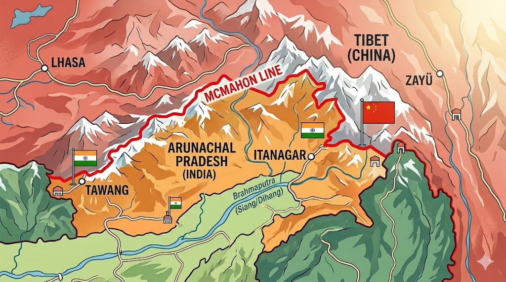
A map illustrating the eastern sector of the India-China border, highlighting the McMahon Line, defined during the 1914 Simla Convention, which remains a key point of contention in the territorial dispute over Arunachal Pradesh
The 1962 Sino-Indian War: A Defining Flashpoint
No event crystallized the India-China Arunachal Pradesh border dispute more dramatically than the Sino-Indian War of October-November 1962. Triggered by escalating patrols and road-building activities along the disputed frontier, the conflict erupted on two fronts: the western sector in Aksai Chin (Ladakh) and the eastern sector in NEFA (Arunachal Pradesh).
In the eastern theater, Chinese forces launched a swift offensive, crossing the McMahon Line and overrunning Indian positions. Tawang fell quickly, and Chinese troops advanced deep into the region, reaching areas perilously close to the Assam plains. Indian forces, hampered by poor logistics, inadequate high-altitude training, and political miscalculations in New Delhi, suffered heavy casualties—estimates place Indian losses at around 4,800 killed, wounded, or missing, compared to roughly 700 on the Chinese side. The war exposed critical vulnerabilities in India’s defense preparedness and shattered the illusion of Himalayan invulnerability.
Yet, just as dramatically as it began, the war ended. On November 21, 1962, China declared a unilateral ceasefire and withdrew its forces from the eastern sector back behind the McMahon Line, while retaining its gains in Aksai Chin. Beijing framed the move as a demonstration of restraint, but analysts point to strategic calculations: the harsh winter terrain made sustained occupation logistically nightmarish, and international pressure—coupled with India’s appeals for Western aid—may have influenced the decision. The withdrawal did not resolve underlying claims; instead, it froze the status quo along the LAC, leaving the Arunachal Pradesh issue unresolved and sowing seeds of enduring mistrust.
The 1962 war remains a painful chapter in Indian collective memory, influencing defense policies and public sentiment toward China to this day. For China, it served as a tactical victory that secured Aksai Chin while signaling resolve on the eastern front without permanent annexation of Arunachal. The conflict underscored how the land dispute could rapidly escalate into open warfare, fundamentally altering India-China political relations for generations.
Post-War Developments and Persistent Tensions
In the decades following 1962, the Arunachal Pradesh border dispute simmered rather than boiled over into full-scale war, but periodic clashes kept it alive. Skirmishes in 1967 (Nathu La and Cho La), 1975 (Tulung La), and 1986-87 (Sumdorong Chu) highlighted ongoing frictions. Diplomatic efforts, including the 1993 Agreement on Peace and Tranquility along the LAC and subsequent confidence-building measures, brought temporary calm but failed to produce a comprehensive boundary settlement.
China’s claims intensified in the 2000s, with officials occasionally describing Arunachal as “southern Tibet” in public statements. India responded by granting statehood to Arunachal Pradesh in 1987 and investing in its development to strengthen local integration. Yet, the core disagreement persisted: India insists on the McMahon Line, while China demands concessions in the east to offset its western holdings.
By the 2010s, the dispute intertwined with broader geopolitical shifts. China’s economic rise and military modernization enabled more assertive patrolling, while India’s Look East (later Act East) policy emphasized Arunachal’s strategic role as a gateway to Southeast Asia. Incidents like the 2017 Doklam standoff (involving Bhutan but linked to eastern sensitivities) and the 2020 Galwan Valley clash in Ladakh further strained ties, though the eastern sector saw relatively fewer direct confrontations. Still, the shadow of Arunachal loomed large, reminding both capitals that unresolved land issues could derail progress elsewhere.
China’s Renaming Strategy: A Tool of Assertion
One of Beijing’s most consistent—and provocative—tactics in the India-China Arunachal Pradesh border dispute has been the periodic standardization of Chinese names for places within the state. Since 2017, China has released multiple lists renaming villages, mountains, rivers, and passes, aiming to reinforce its narrative of historical sovereignty. In 2023, 2024, 2025, and as recently as April 2026, fresh batches of names appeared in official Chinese publications, often drawing on Tibetan linguistic roots to underscore cultural affinity.
India has categorically rejected these moves as “mischievous attempts” to manufacture fictitious claims. In a strong statement on April 12, 2026, the Ministry of External Affairs spokesperson Randhir Jaiswal declared that such actions “cannot alter the undeniable reality” that Arunachal Pradesh remains an integral part of India. New Delhi views the renaming as an effort to alter facts on the ground through cartographic aggression, a low-cost way to sustain pressure without direct military engagement. Beijing, however, frames it as routine administrative standardization, consistent with its sovereignty over “South Tibet.”
This strategy fits into a broader pattern of gray-zone tactics—village construction, map alterations, and rhetorical insistence—that allow China to advance claims incrementally. For India, each renaming episode serves as a reminder of the dispute’s persistence, prompting diplomatic protests and renewed focus on border infrastructure.
India’s Firm Rejection and Strategic Response
India’s position has remained unwavering: Arunachal Pradesh is, was, and will always remain Indian territory. Successive governments have reinforced this through administrative integration, economic development programs, and high-profile visits by leaders to the state. Prime ministerial trips to Tawang and other border areas symbolize political commitment, while infrastructure projects underscore practical control.
India has also pushed back diplomatically against China’s core-interest framing. Recent analyses note Beijing’s expansion of “core interests” to explicitly include Arunachal, signaling a hardening stance that complicates negotiations. Yet New Delhi counters by emphasizing the McMahon Line’s historical legitimacy and the state’s vibrant democratic governance, contrasting it with China’s claims rooted in pre-modern Tibetan administration.
The Infrastructure Race: Roads, Bridges, and Mutual Disagreements
Both nations have turned to infrastructure as a means of asserting presence in the disputed region, leading to what analysts describe as a high-stakes construction race. India has accelerated projects under schemes like the Arunachal Frontier Highway—a massive 1,800-plus-kilometer road network running parallel to the LAC—and the inauguration of tunnels like Sela in 2024. Bridges form a critical component: projects such as the Siyom River bridge and upgrades to existing crossings enhance troop mobility and civilian connectivity. In 2025 alone, India completed dozens of border bridges and roads, signaling resolve to develop frontier areas.
China, for its part, has constructed xiaokang (moderately prosperous) villages along the border, some reportedly on disputed territory, alongside roads and dual-use facilities. These developments enable civilian “border guardians” to support military logistics. Beijing has occasionally protested Indian projects, labeling them provocative, while India has raised concerns over Chinese constructions that appear to encroach on its side of the LAC.
Disagreements over bridges and roads highlight practical frictions. China has, in the past, warned India against projects like the Dhola-Sadiya bridge, arguing they alter the status quo. India views such warnings as interference in sovereign territory. This parallel buildup, while improving local lives, risks miscalculation—each new structure becomes a potential flashpoint in the broader Arunachal Pradesh border dispute.
Impact on Indo-China Political Relations
The land dispute over Arunachal Pradesh remains the single largest impediment to normalized India-China relations. It overshadows economic ties, with bilateral trade exceeding $100 billion annually yet vulnerable to geopolitical shocks. Military disengagements in Ladakh post-2020 have not fully thawed eastern-sector suspicions, and the dispute influences multilateral forums, from BRICS to the Quad.
Strategically, Arunachal’s location—bordering Myanmar and Bhutan, near the Siliguri Corridor—makes it indispensable for India’s northeastern connectivity and national security. For China, control would enhance dominance over the Brahmaputra river system and Tibet’s southern approaches. The issue thus amplifies trust deficits, with each side viewing the other’s actions through a lens of expansionism.
Current Scenario in 2026 and Future Outlook
As of April 2026, the dispute shows no signs of resolution. India’s latest rejection of Chinese renaming underscores continuity in policy, while both sides continue infrastructure pushes amid relative calm along the LAC. Diplomatic channels remain open, but core positions appear entrenched. The war of words persists, yet neither side appears eager for escalation given economic interdependencies and global pressures.

An illustrative photograph of the Sela Tunnel construction site in Arunachal Pradesh, a crucial infrastructure project completed by India to provide all-weather connectivity and strengthen its strategic position in the border region amidst ongoing tensions with China.
Conclusion
The India-China Arunachal Pradesh border dispute exemplifies how historical grievances, territorial claims, and strategic imperatives can entangle two rising powers in perpetual tension. From the unratified McMahon Line and the trauma of 1962 to today’s renaming battles and bridge-building rivalries, the land issue has profoundly shaped political relations—preventing full rapprochement while compelling both nations to invest heavily in frontier defense and development.
Resolving it will demand creative diplomacy, mutual concessions, and recognition that sustainable peace benefits both. Until then, Arunachal Pradesh stands not only as India’s eastern sentinel but as a litmus test for Asia’s future stability. For policymakers, scholars, and citizens alike, understanding this complex saga is essential to appreciating the delicate balance that defines one of the world’s most consequential relationships.